Posted by: oheb | July 6, 2007

Arrival

I’ve always thought of public transit as the best way to experience a city. If my first bus ride says anything about San Diego then I’m in luck!

Scenario: Old Man embarks ahead of me and hands Bus Driver a surprise BiG mAc lunch! Taken aback by this seemingly random act of pure loving kindness, Old Lady, with large smile and a “God Bless You”, hands Old Man a pack of Bits ‘n Bites. Proof that doing good and can only bring you more good (ie. pack of bits ‘n bites). This may have been the nicest thing I’ve ever seen anyone do for a bus driver!

An hour later and I’ve made it to the Island of Coronado where I’m staying. My heart jumps a little when I get to the motel…First Room hasn’t been cleaned (and is in a state of uncleanliness beyond what you would imagine possible from “normal use”). I ask for another room and get upgraded to Second Room. With a desk! I’m much happier and now capable of setting out into San Diego.

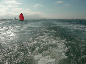
To get to San Diego you have to take a ferry…and this is a major bonus! 15mins to downtown. On the ocean. In the sun.

Boat ride from Coronado

Downtown is an eerie ghost town on a Sunday Afternoon, but the Convention Center is full of fellow GISers (we’re a mixed bag of geeks), and ESRI’s many flags are flying proudly.

ESRI

Now I’ve got my name tag and tote bag, and I’m off to find a burrito and then my way back to the motel to look through my goodie bag…until tomorrow…

Posted by: oheb | July 5, 2007

Technology Keynote – Information Modeling

Weds: 8.30am
Scott Morehouse
ESRI Executive – Software Development

Scott Morehouse, long bearded and clearly very intelligent, gave a Technical Keynote today on Information Modeling.

GIS is an information system, it takes real-world things and creates an abstracted representation of those things. Although they are abstracted, we can apply those representations to the real-world in order to better understand it.

So how did GIS get to where it is today? And where is it going?

Pre-Computer…
Before computers there were Nautical Charts, and Topographic Maps, which provided the precursors for many common GIS concepts. There was also the tile based delivery of imagery, such as the taping together of 9”x9” air photos.

Computer…
Then came the computer, and these well established geographic models had to be transposed to the digital environment. At first the software was I/O based; you put in an input, performed an action on that input, and received an output. It then moved to an Object-Oriented model, where objects had behaviours, and relationships to other objects. That model was then integrated into RDBMS systems. It all still does the same thing as a Topo map, but in a very different way.

Post-Computer…
Not yet. But the next generation of applications is using the web as an output for its representations. The web does many things well (searching, disseminating, messaging, facilitating collaboration, and dealing with tons of unstructured information), and new applications will have to take advantage of these things, and find ways around what the web doesn’t do well (information security, and structured information).

ESRI is looking at these emerging issues, and some of the things that Scott’s division is working on are:

  • Cataloguing / Tagging
  • geoRSS messages (geoTagging)
  • Semantic Networks and Ontologies
  • Integration with Business Intelligence systems
Posted by: oheb | July 5, 2007

Fish and Oceans Related Paper Sessions


Tues: 3.15pm – Steelhead Fisheries Management of Lower Santa Ynez River
Weds: 10.15am – Web-Based Oceans Applications

Echoing what Chris Thomas had said in an earlier session, the GIS Community is way behind the technology. I attended these sessions with the expectation that I would find all sorts of new approaches to GIS analysis and web mapping, specific to our work at DFO. Instead, I found that the groups presenting were only as advanced, or not as advanced as us. Murray Manson’s analysis work would have blown minds down here. And, who knew, MAPSTER is cutting edge!

One interesting point raised here that I later heard in Scott Morehouse’s Technology Keynote is regarding the need for a well-developed Semantic Network.

Links:

Posted by: oheb | July 5, 2007

ArcWeb Services

Tues: 1.30pm
Weds: 3.15pm
ESRI Web Services Division

The newest and fastest growing division supposedly…ArcWeb Services just released the ArcWeb Explorer 2 (AWX 2.0) API.

ArcWeb Services are, according to their website, a collection of tools that enable users to integrate mapping, routing, and geographic reporting into their Web, wireless, or desktop applications. Basically it gives you an AJAX enabled map window, onto which you can place objects. The spatial data and the objects can come from any number of sources.

AWX 2.0 is built on the Flash Player 9, a new player with a “just-in-time” compiler, which has apparently boosted the display speed significantly since the days of AWX 1.0. The Flash player resides on the client, and most of the work is done by the client; projection, measurements, etc. As home computers have skyrocketed in power and speed, this ability has provided significant improvement in display speeds.

All of this leads to THE MASHUP! Possibly a real multi-media experience.

Somewhere in here is the future of GIS applications…You have your beautifully designed webpage, branded in your special CSS, javascript, Flash movies, etc and the webpage has a MAP window that contains your base data, local and pulled from a variety of sources. On top of those base layers you place more data from a host of other map services, you attach graphics, links, video and sound to locations, you pull in geoRSS feeds that place real-time events onto the map, you pull in custom routing, buffering, geocoding tools, and on and on…And all of this happens with smooth panning and quick refreshes…

So how does an organization get into this without serious time and resources? Well, here’s that gap between the technology and the community.

Posted by: oheb | July 5, 2007

Future of Government Online

Tues: 8.30am
Christopher Thomas
ESRI – Government Technology

So this guy is in charge of ESRI grants. Every year ESRI gives $100K’s worth of hardware and software to organizations that apply for them. Something to keep in mind for next year.

This session was all about trends in GIS, geared mostly towards government, but the information would apply to any organization. The speaker identified three main points that had an impact on how GIS services are transforming:

  • Standards: Web and Interoperability Standards are becoming more formalized, stronger, and easier for organizations to implement
  • Data Repositories: Organizations are increasingly storing their data in large RDBMS systems (Data Fusion Centers, Data Portals) that can serve out data quickly and efficiently
  • Web Services: These services are now becoming more robust, better designed, and better understood by the GIS community. They provide an easy way to pull data out of and push data in to RDBMS systems

With these changes has come a shift in how MOU’s are handled, and they have proliferated through the States as it has become easier for organizations to keep ownership of their data and serve it out as a service to those who want it.

ESRI is following all three of these points with an emerging focus on Web Services. He noted that the technology was way ahead of the GIS community and he had yet to see a truly innovative and sophisticated example to showcase the possibilities. This was reinforced with my experience in User presented “Paper Sessions”.

He also noted that in the past it was the resource industry and government that lead the way in GIS technology, but it has now become clear that they are falling behind; the new leaders in GIS innovation are from the logistics, business analytics, and real estate sectors.

Posted by: oheb | June 21, 2007

The Big Questions…Answered (partially)

1) What’s the deal with ArcGIS Explorer?
I’m not entirely sure. What I’ve gathered so far is this: Explorer is a desktop application that can be customized with your own data, tools, and tasks. To extend it, .NET must be used; Java is not supported. Explorer can consume services from ArcGIS Server, ArcIMS, GeoRSS, etc. It’s a powerful tool, obviously, but some serious discussion would have to happen around whether it’s something that would be useful for us right now.

1) What’s with the Metadata Service in 9.2?
OK, this was a major relief. After questioning many ESRI staff I feel confident that ArcIMS 9.2 DOES, in fact, have a Metadata Service. Yes, that’s right! A Metadata Service exists. What this means is that we can upgrade to ArcGIS 9.2, ArcSDE 9.2, and ArcIMS 9.2 without losing metadata. What does NOT exist is a Metadata Service for ArcGIS Server 9.2, nor will it exist for Server 9.3 (maybe for 9.4?). The reason for this is that a major re-architecture of the catalog system is required to support the ISO 19115 and ISO 19119, for metadata for data and services, respectively. Also note in this OGC Interoperability Matrix that SLD and Catalog 2 support is there for 9.2.

3) Java vs .NET
All aspects of ArcGIS can be extended using either the Java or .NET framework….EXCEPT ArcGIS Explorer and ArcGIS Mobile; any customizations within these frameworks must be done in .NET

4) The IMF
Though I think we currently license the IMF through MoxiMedia, an upgrade to IMF 6.0 would transfer that to GeoCortex in Victoria. The object model for ArcGIS Server is now exposed so customizations can now take place much the same way we currently customize the IMF. More conversation with the GeoCortex people is needed.

TO BE CONTINUED…

Posted by: oheb | June 21, 2007

Myth?

San Diegans walk bolt upright.

If you’re from Vancouver and you’ve been in San Diego for a few days, the first thing you notice is that the weather is totally predictable. The sun is always shining and nothing ever seems to fall from the sky.

A funny story about a guy from San Diego. On a trip to Detroit with a friend from Toronto, he arrives in a blizzard. Walking to the hotel, doing everything he can to see even a few steps ahead of himself, he finally stops his friend and screams, “I can’t see anything!”. To which she responds, “Put your head down.”.

Walking home.

Posted by: oheb | June 21, 2007

Advanced Oracle Administration

Tues: 10.15am
ESRI Database Specialists

Most of this session was over-my-head but I did get the most important information…

Cursors: Oracle assigns cursors to each SQL statement run on the database. In ArcGIS, each layer is assigned 8 cursors to deal with the various SQL statements being run against it. This means that an MXD with 30 layers would consume 240 cursors. It is beneficial to set a few parameters for how Oracle handles ArcSDE’s cursors

  • open_cursors: 2000+ (the number of cursors allowed)
  • session_cached_cursors: 100+
  • cursor_sharing: exact (meaning cursors can be reused but only if the SQL is exactly the same)
  • cursor_space_for_time: true (means Oracle can’t steal cursors for its own use)

LogFiles: Apparently, any issues with shared log files that used to exist have been solved with 9.0+. One interesting note is that the SDE_LOGFILE_DATA table needs to be tweaked a bit for optimal performance, statistics should be dropped on that table and dynamic sampling should be turned on and set to 2.

Posted by: oheb | June 20, 2007

New for ArcGIS 9.2

Three things have, so far, really stood out for me regarding the new release of ArcGIS.

1) Mashups: This is a silly term for some really cool possibilities. A Mashup is, as defined on Wikipedia, “a website or application that combines content from more than one source into an integrated experience.”. This means you can author your own web services, combine them with other web services, such as Google Maps, or ArcWeb Routing Services, and serve them out as a web application. The user experiences this as one integrated tool. It’s like this…you create your application however you want, integrating any number of services that follow the Web Standards; ArcGIS is just one service that you tap into. It is worth noting that ArcWeb Services are also based on AJAX which allows for the smooth panning you experience with Google.

2) Cached Map Services: I’m going to have to do more exploring in this regard but the simplistic version is this: You can cache tiles of data that are accessed often by users, potentially increasing the performance of your display and queries by “lots”.

3) Security: You can now set up roles and users, and it seems to be quite easy. You can do this at the tool or service level too. Meaning, maybe you have an application that is accessible to the public, but within that application you have tools that you want to limit to an internal selection of users, or maybe their are sensitive layers that you want to limit access to. You can do all that.

Posted by: oheb | June 19, 2007

Take Note!

Cartography: Apparently, presentation is important…ESRI also has a Mapping Center with a wealth of information on all the cartographic details that go into a map. Like gradient filles for your polygons, which is actually pretty awesome; allows for same-coloured polygons, side-by-side, without outlines! Woooooo!

Paper Butterflies

Internal: Apparently, ESRI will be making available their “internal” Knowledge Base at the ESRI Support Site. Meaning that all bugs and known problems / solutions will be transparent to the user community. This is good news as calls to the support center can be a hair yanking experience.

Free Data!: ESRI now has data available online for users to pull into their applications, mostly for the US (like free 1 meter imagery for Continental US!), but should be explored for Canadian data. This is an interesting thing to think about as it may foreshadow how web applications may look in the future.

GeoRSS: The Open GeoSpatial Consortium is thinking of making geoRSS an OGC Standard. RSS is a web feed format that allows you to pull in data from other websites; the information you’re taking from the feed is automatically updated for you. geoRSS simply adds Lat and Long XML tags to it, meaning the information can be mapped to a point.

Older Posts »

Categories